"Using wireless connectivity and machine learning, real-time data will reduce the billions of dollars in costs stemming from road congestion."
Rob Lauer
Director of Developer Relations
Blues Wireless
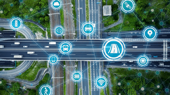
Cities around the world are experiencing ongoing population growth. As people move in, municipal infrastructure is stressed. IoT-based smart city solutions are helping cities promote modern economic development, improve city infrastructure, increase environmental awareness, and optimize usage of public resources. Using machine learning at the edge, cities can tackle one of the most expensive and impactful side effects of rapid growth: increased road congestion.
When building proof-of-concept or prototype IoT devices it is important to spend most of your time on features that solve the challenges at hand, not utility functionality. Blues Wireless Notecard is the simplest, and most cost-effective way to add connectivity to IoT devices. Simply plug Notecard into your existing hardware and it will connect your device to the cellular network automatically, ready to transmit and receive data.
Using the Notecard, you can build an edge device using machine learning and image recognition with only 100 lines of code.
Download PDF
View Hackster Project
Get Source Code
Urban Area Congestion
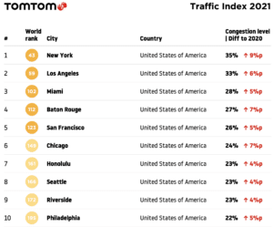
TomTom
As of 2020, 56% of the global population lived in urban areas, and that number was even higher in the developed world (79%). Urbanization presents unique challenges to city planners and politicians, as increasing populations stress municipal infrastructure and services. One of the most visible impacts of a growing population is the increase in traffic. According to the TomTom Traffic Index, in 2021 New York City had the highest congestion level in the United States at 35%. This means that a 30-minute trip during peak hours will take 35% more time than it would during the city’s off-hours. This translates to an additional 10.5 minutes of extra travel time for every 30 minutes of driving.
Aside from the individual frustration that traffic jams cause, there are myriad impacts to the community. Road congestion has economic, environmental, and human costs:
Commuter: time, fuel, quality of life, vehicle maintenance
Environmental & Public Health: CO2, fuel, death and illness
Economic Competitiveness: access to jobs, airport delays
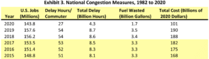
Traffic congestion interferes with emergency vehicles, increases the number of accidents, increases air pollution, and affects productivity – and these all have dollar signs attached. This places economic strain on cities and states in the hundreds of billions of dollars:
So how can these issues be addressed? Often through public-private partnerships, deploying connected devices can provide data needed to solve the challenges unique to an area. Thoughtful implementation of IoT systems is transforming cities around the world into smart cities.
Smart City Traffic Management with the IoT
In smart cities, IoT solutions collect and transmit data to optimize infrastructure and services. This empowers local governments to better engage citizens, manage services, and save tax dollars. Networks of sensor-enabled devices collect data on energy usage, traffic volume and patterns, pollution levels, and other events which are analyzed and used to understand usage and predict patterns. Uses of IoT in smart city management include:
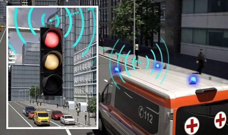
Smart Traffic - IoT systems can use machine learning and CCTV cameras to monitor and regulate traffic by changing traffic lights based on the volume of vehicles.
Smart Parking - Enabling real-time parking availability reduces congestion and increases satisfaction of public parking resources.
Smart Streetlights - Smart streetlights can auto-adjust dimness to save energy and can listen for breaking glass (from accidents or break-ins) or gunshots and call for law enforcement.
Smart Sanitation - From street sweeping to waste collection, there are countless ways that a city can utilize IoT devices and sensor data to better manage how cleanliness is maintained.
Smart Emergency Response - Cameras and sensors capture and share video, audio, and vehicle location, giving first responders and dispatchers real-time data for training and planning. Smart cameras can see accidents and trigger emergency response.
As the technology becomes more ubiquitous, cities are using the IoT to improve livability and drive economic growth, and there is massive investment in these efforts. Last year, the University of Michigan received $20 million from government and corporate partners to implement 20+ smart intersections in Ann Arbor. Using cellular connectivity, the systems gather and transmit real-time data to connected cars to manage traffic flow and reduce congestion, leading to significant savings.
According to a Juniper Research study, smart traffic management systems could save cities $277 billion by 2025 through reducing emissions and congestion. The report predicts over 95% of savings will be made by reducing traffic congestion. North America and Europe are anticipated to account for over 75% of all savings due to increasing investment in smart traffic management and high vehicle usage.
Building an Image Classification IoT Device
Measuring traffic density requires a way to detect vehicles, assess their speed, and track vehicles traveling through monitored zones. Image processing generally requires heavy data processing, specifically when you get into recording and transmitting image files in real time. To build a traffic management device for smart city deployment, you need more efficient and less costly image processing.
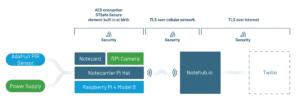
Follow this project if you are looking to create a IoT device prototype that uses machine learning at the edge for low bandwidth image classification. The device uses a Pi camera and predefined image classification models to identify what’s recorded. Data is pumped to a cloud service using the Blues Wireless cellular Notecard System on a Module, and established SMS alerts are routed through Twilio.
The Notecard is the quickest and easiest way to add cellular connectivity to this device, and it comes with 500 MB of data usable over 10 years. You can find the complete project assembly instructions on Hackster and the full source code on GitHub.
Assemble the hardware for a motion-activated image detection edge device.
Build, tune, and deploy an image classification model.
Send results to the cloud.
Create a route to receive text message alerts when readings fall out of normal range. (Optional)
Using Machine Learning at the Edge
Machine learning models generate inferences based on known data. In this case, you’ll be training the model to create an inference about the things you want it to recognize, and thus the images you want to capture.
By using Blues Wireless, your inferencing model results can be pumped to any cloud app with lightweight, secure image data. Blues Wireless provides edge-to-cloud IoT infrastructure, with hardware, firmware, and cloud communication components, and can be embedded into any device:
Notecard: A tiny 30mm x 35mm System on a Module (SoM), the Notecard is a cellular and GPS-enabled device-to-cloud secure data-pump that comes with 500 MB of data and 10 years of cellular starting at $49.
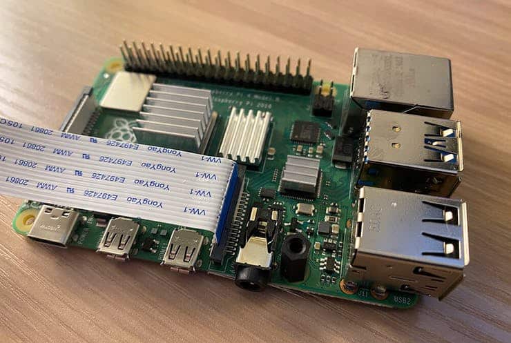
Notecarrier: To make integration in an existing project easier, Blues Wireless provides host boards called Notecarriers. For this project, use the Notecarrier Pi HAT and put it between the PiJuice Hat and Raspberry Pi.
Notehub.io: On the cloud side, the Notecard ships preconfigured to communicate with Notehub, which enables secure data flow from device-to-cloud. Notecards are assigned to a project in Notehub. Notehub can then route data from these projects to your cloud of choice or integrate with third-party services like Twilio.
With the PIR sensor triggered, the device is activated to snap a picture. You’ll start by activating the camera and specifying where in the file system you want the captured image to be saved.
Then, specify the location of the machine learning model and label map used to map the results from the model to an actual image target name (in this project, a bird name). Carrying on, you’ll set a confidence threshold and follow these next steps:
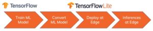
Encapsulate your model by initializing the TensorFlow interpreter.
Open the camera and adjust light settings.
Snap a picture and save it to the file system.
Run the image classification function and allow TensorFlow Lite to analyze the image.
If the confidence of the match is greater than the established threshold, the image is sent to the cloud.
Applications of This Project
Traffic management has increasingly become complex as urban populations increase. Machine learning at the edge can improve accuracy and efficiency in the measurement, prediction, and prevention of road congestion. When today’s city planners are working to incorporate sophisticated systems to transform their citizens’ lives, they should also consider how this collected data is reliably and securely delivered to their cloud. It only makes sense to use a cellular IoT solution using the Blues Wireless Notecard.
In addition to smart city traffic management, there are diverse use cases for this type of device, including:
People counting for retail
Construction site safety compliance
Parking deck management
Environmental disaster hazmat response
Severe weather alerting and response
Facial recognition for counterterrorism efforts
Ready to Discuss Your Project With Us?
Blues Wireless makes it easy to make connected devices. In the article above, you’ve seen how little effort it takes to build an initial proof-of-concept device that reports sensor data over the cellular network. In some cases, it’s best to start with one of our proof-of-concept applications, then swap out sensors or cloud apps until you get what you want. In others, it would be best to take a different tact entirely.
We can help. Our team of experts will discuss your project idea with you and help you find the shortest path to a proof-of-concept device so you can get your product or device connected to your cloud.
I need to measure different data. How can I customize this device?
This device is fully customizable by integrating different sensors and adding the appropriate libraries to the device.
If you have questions about acquisition or compatibility, please Contact Us.
Which microcontrollers does the Blues Wireless Notecard support?
The Notecard is compatible with any microcontroller (MCU) from an 8-bit Arduino to 32-bit ESP32 or STM32 and every major Single Board Computer (SBC) platform. Some popular examples include the Adafruit Huzzah32, STM32 Nucleo, Arduino Nano, ESP32-WROOM, among many others. The Notecard communicates over either I2C or UART, so it acts as a peripheral that you can connect to a product’s existing I2C bus or UART connection.
It’s also possible to communicate with the Notecard from any embedded language, including compiled languages like C and C++, to interpreted languages like Python and JavaScript.
Which cellular networks does the Blues Wireless Notecard utilize?
Different models of the Blues Wireless Notecard are available that connect to LTE-M, NB-IoT, and Cat-1 networks globally. When LTE-M, NB-IoT, or Cat-1 aren’t available, the Notecard is also supported by UMTS/HSPA+ and GSM/GPRS/EDGE wireless standards.
I need a fleet of devices. Are there options for me to buy a larger quantity?
Yes! Blues Wireless can support your project whether you need 10 devices or 10,000. We also have relationships with device building firms and contract manufacturers to help bring your vision to life.
Which countries does the Blues Wireless Notecard support?
Global coverage is available in 135 countries, with direct support provided by leading providers and carriers. For a full list, please see our documentation article on Notecard’s supported countries.
Which wireless standards are used by the Blues Wireless Notecard?
Various Notecard models are available that connect to LTE-M, NB-IoT, and Cat-1 networks. In global regions without these capabilities, coverage is also supported by UMTS/HSPA+ and GSM/GPRS/EDGE wireless standards.
Does the Blues Wireless Notecard require a Notecarrier to function?
No! The Blues Wireless Notecard is a small 30mm x 35mm system on module (SoM) that is able to be embedded in any IoT project on its own via its M.2 edge connector.
However, Blues Wireless provides a variety of Notecarrier host boards for easily adding cellular connectivity to a new or existing IoT solution for prototyping purposes. The Notecarrier also provides antennae for both the GPS and cellular capabilities of the Cellular Notecard (and the cellular antenna is also compatible with the Wi-Fi Notecard).